You’ve Seen It in Encanto—Now Hike the Real Colombian Valley With the World’s Tallest Palm Trees
If you’re dreaming of lush landscapes and surreal natural beauty, let me introduce you to one of Colombia’s most magical places.
The Cocora Valley (or Valle de Cocora in Spanish) is a true bucket list destination in Colombia—and honestly, it feels like something out of a fairytale. Towering wax palms rise out of the lush green hillsides, mist drifts through the valleys, and the whole landscape feels almost too magical to be real.
Hiking through the Cocora Valley is one of the main reasons people visit this region of Colombia and the nearby town of Salento. It was definitely the driving factor for our trip—and let me tell you, it absolutely lived up to the hype.
Fun fact: Disney’s Encanto is actually set in the Cocora Valley. The creators visited different regions of Colombia while researching for the film, and when they saw Cocora, they knew—it just felt like the place. And honestly, I get it. With scenery this enchanting, it really does feel like stepping into a storybook.
What is the Cocora Valley (Valle de Cocora) famous for?

In the Cocora Valley, you can see the Quindío wax palm trees, which are the tallest palms in the world! They are tall, really skinny, and can grow up to 200 feet high. The wax palms are also the national symbol of Colombia.
You will see the majority of these wax palms in the Bosque de Palmas section (the Palm Grove), which is towards the beginning of the Cocora Valley trail.
However, you get a lot more than just the Palm Grove if you do the entire Cocora Valley loop trail! You’ll hike by a river, cross several rickety bridges, hike through a dense, lush rainforest, visit a hummingbird house, and see some beautiful landscapes and mountain peaks.
How Long is the Cocora Valley Hike?
We tracked our hike with the Alltrails app, and according to the app, we hiked about 8 miles (12 km), with about 2500 feet (762 meters) of elevation gain. It took us about 7 hours to do the hike, which included 4 hours 41 minutes of hiking the Cocora Valley and just over 2 hours of stops.
We made some long stops at the two official Palm Grove viewpoints, plus another stop at an unofficial, yet pretty, lookout in the Palm Grove, and then also had a decent break at the hummingbird house.
Cocora Valley Hike Map

Just Hike to the Palm Grove and then Back Out

If you aren’t up for a big hike, or the weather is just really bad, you can also just hike to the Palm Grove! There’s no shame in hitting just the high points and calling it good!
Further, the whole loop is several hours and requires you to be in decent shape. If time, dexterity, or conditioning are a concern, just doing the shorter hike hike is probably the best choice.
If it has rained a lot recently, you also might consider skipping the full loops as the mud gets really intense. But, the hike just to the viewpoints should still be doable in most weather conditions.
Here’s What Doing the Cocora Valley Hike is Like
The willy jeeps will drop you off in an unpaved parking lot. Right away, you will choose the clockwise or counterclockwise direction. While you can do either way, since we did the clockwise route, we’ll describe that here.
Continue up the road for 10-15 minutes until you reach a shack and a sign that says “Sendero Bosque de Palmas” next to a small set of stairs. You’ll take a right, climbing the stairs, and then pay the entrance fee (10,000 COP per person). This is the entry to the Bosque de Palmas (the Palm Grove).

Here, you’ll really start to see the palms surrounding you. We were hiking here at about 7:30am, so the morning was new and the area was quiet. We were surrounded by rolling green hills, and sometimes flowering plants. Up ahead, we could see the wax palms, tall, skinny, and towering over us.

As you hike, you’ll pass a lot of really beautiful spots:


The Miradors
Another 15 or so minutes, and a decent climb, will bring you to the first official lookout spot: Mirador #1. At the viewpoint, climb down the stairs for the best vistas over the valley.


Mirador #2
Another 10 minutes brings you to Mirador #2. I loved this one, since the hill dropped off sharply by the viewpoint and there were a lot of palms all clustered on that ridge. This is the viewpoint that offers the “classic” views of the Cocora Valley. You’ll often see this spot reflected on souvenirs.

At both of these Miradors, there isn’t a fence, so you can get off the path and closer to the palm trees.

After the Palm Grove
After Mirador 2, you leave the Palm Grove area, and the landscape shifts away from pastures and palms and more into jungle forest (though you can often still see some palms through the forest). It’s a really cool shift in scenery as you continue hiking up and deeper into the Cocora Valley forest and the mountains.

There is a little snack shack about 15-20 minutes past the second lookout point and before the highest point on the trail. During our hike, a lot of clouds were rolling in, coating the palm trees in a misty haze. This really made the palms look like something out of a magical world!
Note: This snack shack is where you will pay a 10,000 COP entrance fee to the Palm Grove if you hike in the counter-clockwise direction.

Around the halfway point of the trail, you’ll be in an area of tall pine trees – it actually reminded me a lot of Colorado!

After this section of forest, you’ll pass by a fence and a couple of buildings. This is generally considered the mid-point, and where the trail really changed pretty dramatically. Up to this point, the trail was dry, firm, and decently wide, and while there was an incline, it was very straightforward to climb.
The Downward Stretch
Once we started hiking down from the midpoint, the trail became almost “deep.” Erosion had carved the path deep into the hillside, and the trail becomes much, much, much wetter.
There were a lot of sections where the trail actually was almost a little stream. You can walk through without getting soaked – there are plenty of rocks – but it certainly made walking down … interesting.

These stream-like areas are interspersed with sections that were just plain muddy. Extremely muddy. It was very slick and tricky to walk down and through it. This area also had some bigger rocks on the trail, making for larger steps down.
Despite the technical nature of the climb down, we really were having a great time. The whole thing felt like a big adventure!

Thankfully, the path was never overgrown with brush, it was always cleared, and it was straightforward where to go. Through this downward section especially, the forest around us felt so raw and wild. The foliage around us was thick brush with a wide variety of unique, tropical plants.
As you descend farther, you actually start hiking right along the Quindio river, which was extremely pleasant. This river has a lot of rocks in it, which made for some good cascading moments. It was really pretty framed by all the greenery. Despite the fact it was making the trail super muddy, I loved being by the river.
Acaime (The Hummingbird House)
When the trail brings you to the river, there’s a jutoff to go up to the Hummingbird house (Acaime in Spanish) . It’s about a 1km/0.6 mile detour, one way. It’s a fairly steep climb up to the House (you gain 500 feet of elevation in that 0.6mile). Be aware that the signs do all say “Acaime”, so make sure to watch for that as you’re looking for the turnoff.
One thing to note is that on the way up to the Hummingbird house, you will cross the river. When you first come to the river, it appears as though you cross it and the path continues forward. However, on the other side, you quickly realize it’s a dead end.
The path actually hooks back around (head up the stream, then back on the same side of the bank that you crossed). Just head upstream a little longer and the real crossing will be clear. It’s a little confusing, but the trail does continue!

At the Hummingbird House, you’ll find a shelter with several benches and tables to relax at. To enter, you pay a 15,000 COP entrance fee. Along with access to the shelter, some women will serve complimentary coffee, hot chocolate, or sugar cane water.

Of course, it isn’t called the hummingbird house for nothing. There are two little birdhouses with a bowl of sugar water in them that attracts the hummingbirds. They quite like the water, so there are always several birds flitting around the two houses. It’s kind of fun to watch them drink, flit around, and come back for more.
While we talked to several people who really liked the Hummingbird House…. it wasn’t worth the stop, in our opinion.
It was a fairly steep, muddy climb up to the house, and took longer and more effort than I expected. While it was cool to see the birds, it also was really just a bowl of water in the trees, and was a little underwhelming. Matthew enjoyed it a bit more (and I will say I’m less of a bird person), but this one was just meh for me, and I wouldn’t do it again.
Back on the Trail
Once you get back on the main trail after the Hummingbird House, the trail starts crisscrossing the river using a series of rickety bridges. These bridges are one person at a time suspension bridges, and were just so fun.
I know some people found these to be scary, but this was one of my favorite parts of the Cocora Valley hike!

Watch out for the Cascada Bosque de Niebla, a partially hidden waterfall on the Quindio River. Despite being partially obscured by the brush (or maybe in spite of it!) the waterfall was very beautiful. You’ll just pass by the waterfall as you hike, there’s no way to get closer to it.

Finally, you emerge victorious from the cloud forest! You’re not done yet, though; the trail does continue for another 1-2 kilometers. This section mirrors the beginning of the Cocora Valley hike, with the path cutting through grassy grazing land, and some wax palms dotting the landscape. Every so often you see cows in their pastures – sometimes right up by the fence.


About 15 minutes before the end of the hike, you pay another 5,000 COP to exit the Cocora Valley, and continue on to the parking lot.
Congratulations! You completed the Cocora Valley hike!
How Do I Get to the Cocora Valley from Salento?
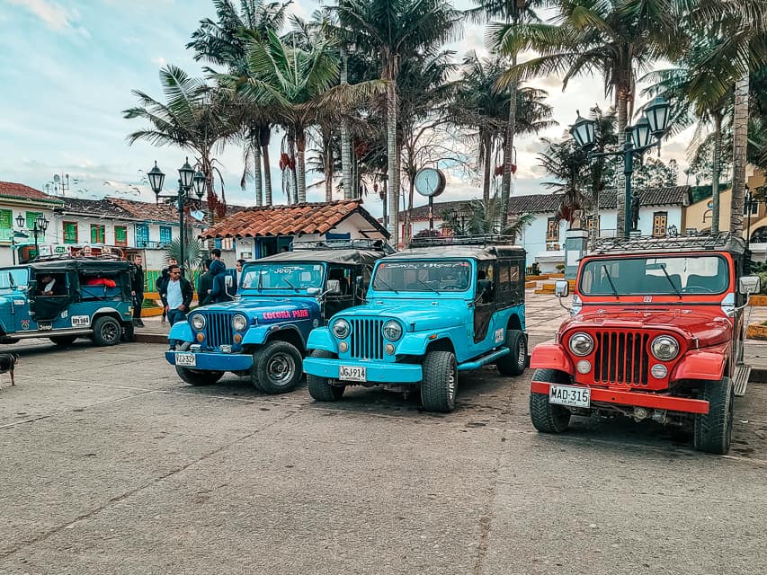
While you can take a taxi (or drive yourself if you rented a car), the vast majority of people who come to the Cocora Valley take a willy jeep from the nearby town of Salento.
You can buy willy jeep tickets the day of from the main square (Plaza de Bolivar) in Salento. A schedule is posted on the ticket shack, so you can consult the times ahead of time. The schedule says that the willys leave every half an hour, but in actuality, they leave as soon as the next jeep is full, whether that is in 5 minutes or 30 minutes.
The schedule does change a little bit throughout the year, but when we visited, the earliest departure was at 6:30am, and the latest departure was at 5:30pm (with the latest pickup from the valley at 6:30pm).
Read More: 14 Amazing Things to Do in Salento, Colombia (A Travel Guide)
Getting Back Into Town

When you’re done with the hike, you will catch a willy back into town at the same spot you were dropped off. Note that by afternoon, people are finishing the hike faster than the jeeps can take them back into town, so a pretty long line can form.
Again, despite the posted times on the ticket shack in Salento (which say willys leave every half an hour from the Cocora Valley), the jeeps come and go based on the ebb and flow of the crowd.
There is a bathroom (1000 COP) you can use at the shops by the parking lot.
Horseback Riding in the Cocora Valley
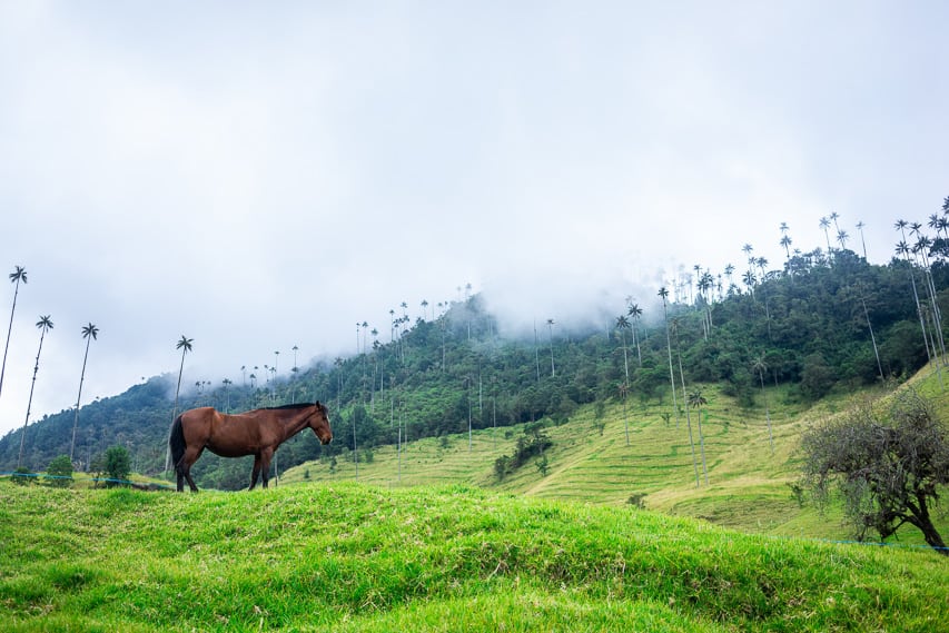
Horseback riding is one really fun and popular way to experience Salento and/or the Cocora Valley. This is a great option if you don’t want to hike, but still want to see the wax palms and the sites.
However, it could still be a good option for you even if you also do the Cocora Valley hike separately, as the horse back riding path is somewhat different from the footpath. On this horse ride, you’ll visit the Wax Palm Grove, then go through a farm, cross the river, and go on horse paths up to viewpoints high in the mountains.
>>Check prices and availability for this horse-riding experience here
Practical Information about the Cocora Valley Hike
When Should I Hike the Cocora Valley?
The dry season in Salento is from December-February, with another drier season from mid-June to mid-September. These are the best times of year to hike the Cocora Valley, as the trails will be drier and easier to navigate.
Expect much muddier conditions on the trail in the fall and spring months, which are the rainy season in Salento.
However, if you are visiting during the rainy season, I would still plan to do the hike! Just be prepared with a poncho and some really good hiking boots.
Additionally, even if you are hiking during the dry season, know that since the Cocora Valley is nestled high in the Andes Mountains, rain can and does still occur regularly throughtout the entire year.
A Few Other Weather Variables to Consider

The mountains of the Cocora Valley, like all of Colombia, are frequently visited by clouds. These will form throughout the day due to the high humidity, even if there are not active weather systems moving through the area.
Due to this unpredictability, if the viewpoints are clear when you start, I would go clockwise. We saw clouds rolling in, obscuring the viewpoints just after we were there, but since we had gone right away, we were able to enjoy the clear views.
You might gauge the weather to see whether it’s better to start or end at the palms, depending on what the clouds are doing. If you want to do the full loop, you can go enjoy it if you see clouds at the beginning and you may find that it is clearer when you end.
As mentioned earlier, when we went it hadn’t rained for several days beforehand, and the trail was still quite muddy on the second half. If it has been very rainy lately, the trail is going to be an extremely muddy mess.
Be prepared for deep patches of mud that will go up several inches on your shoes. If that is a deterrent, you can always just do the hike up to the two miradors and turn around (this would be starting out on the clockwise route).
What Time Should I Go To Cocora Valley?
The earlier you start hiking the Cocora Valley, the less people you will see. However, if you start around noon or early afternoon, you will also have less people with you as you are finishing the hike. Just make sure you arrive back at the parking lot in time to pick up the last jeep into town, or you’ll have a very long walk back into town.
I would also recommend trying to not do the hike on a weekend or a holiday, as the crowds can be very heavy. Going mid-week will definitely have lower crowds on the trail.
What Should I Wear To Do the Cocora Valley Hike

For sure bring the best hiking shoes/boots/sneakers that you have and ones that have good traction and grip. If you don’t have hiking boots, I would choose your sneakers with the best traction and that are the most water-resistant. No matter which direction or what season you go, the trail will likely be slick in some spots.
What Animals Live in the Cocora Valley
There are a lot of interesting animals that live deeper in the mountains of the Los Nevados National Park. Most of these animals are farther back in the forest, and many are nocturnal, but it is possible to see them while you are hiking the Cocora Valley. These animals include:
- Pumas
- Bears
- Ocelots
- Coati
- Horses
- SO MANY BIRDS (did you know that Colombia has the most species of birds in the world?)
- Sloths
- Monkeys
- Mountain Tapir
Read More: Where to Stay in Salento (3 Best Areas + Hotel Recs)
Is the Cocora Valley Safe?
This is a very safe hike and area to be in. There are a lot of other people hiking the Cocora Valley (less if you come first thing or late afternoon), so there are plenty of people on the trail. We felt perfectly fine on the trail, with no safety concerns.
Final Thoughts on Doing the Cocora Valley Hike
If you are in decent physical shape, I would absolutely recommend the Cocora Valley hike. We loved the beautiful vistas and landscapes, the stunning wax palms, and the adventurous nature of the trail. It’s absolutely worth visiting and I would do it again in a heartbeat!